

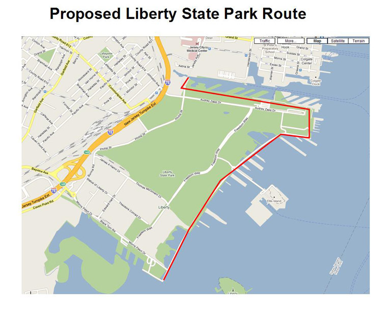
Starting at Flag Plaza east of the Visitors’ Center at the southern corner of Liberty State Park, the trail follows a short distance out to the
Hudson Harbor waterfront and Liberty Walk to go north to the former – Central Railroad of New Jersey station, now a museum and terminal
for ferries to the Statue of Liberty and Ellis Island. West of the station the trail leads along the former Morris Canal Big Basin to the
basin’s end where the trail crosses Mill Creek to Jersey Avenue, Jersey City.
Highlights:
Access to Liberty State Park:
Liberty Park Water Taxi from lower Manhattan Light Rail from Exchange Place, Jersey City N.J. Turnpike to Exit 14B
Parking:
Mostly free; fee may apply at large lot west of CRR station; two hour free parking next to station.
Rest Rooms:
Visitors’ Center CRR Station
The following map shows the plan for a coordinated signage route being worked out with the
Jersey City Division of City Planning, the East Coast Greenway, and the Hudson River Waterfront Walkway.
Photos are located below the map. The main route through downtown Jersey City follows the Hudson River Waterfront Walkway
for approximately two miles along the river, with superb views of the Morris Canal, Korean War Memorial,
Colgate Watch Tower, and of course Manhattan.
A secondary ‘Historic Route’ follows Jersey Avenue past a number of notable city landmarks, and together with the
main route serves to create a roughly three mile loop around downtown Jersey City.
For those who wish to travel the trail through to Newark, the official connecting (thru) route ends at the
Journal Square PATH station where one can board the PATH train to Newark Penn Station.
Those who prefer to walk the to-be-completed ‘on the ground’ connecting route to Newark along
the Lincoln Highway (Rte 1&9), can proceed along the optional walking route through the Bergen District
of Jersey City, past several historic sites, and through Lincoln Park and Lincoln Park West.
Directions:
At the west end of the Morris Canal Big Basin the trail turns north, crosses Mill Creek on an old railroad bridge and then onto Jersey Avenue for a short distance.
At Grand St, it turns east for several blocks, bypassing a portion of the HRWW that has yet to be completed. The trail turns south at Van Vorst Street
and meets up with the HRWW on the northern bank of the old Morris Canal.
The trail then follows the HRWW as it winds its way up the Hudson River, offering stunning views of the Manhattan Skyline.
It continues north to Sixth Street, where it turns left (west) and joins the East Coast Greenway, following the historic Harsemus Stem
(Sixth Street) Embankment, a unique abandoned railroad that rises 30 to 40 feet above the surrounding community of historic brownstones.
The trail continues west along Sixth Street and unto Newark Ave, then along Pavonia Avenue and west along Summit Ave for a short distance
where it enters the back (west) entrance to the Journal Square PATH train station, where one can board the subway for a 15 minute ride to Penn Station in Newark.
The dotted lines in the map above show the optional long-term ‘on-the-ground’ route which proceeds along Baldwin and Belmont avenues,
and through Lincoln Park and Lincoln Park West. This portion of the trail currently terminates in Lincoln Park West, at an opening to
the Lincoln Highway adjoining a baseball field. The route to Newark is currently overgrown with weeds, but there are plans in place
crafted by Jersey City Division of City Planning and the NJ DOT to improve the sidewalk along the roughly 2-1/2 mile stretch of the Lincoln Highway
between Jersey City and Raymond Boulevard (Doremus Avenue) in Newark (see ‘JERSEY CITY TO NEWARK CROSSINGS’ section of the Trail Description
under ‘Liberty State Park and Jersey City.’
Highlights: The handsome quarters of the Jersey City Art Museum at 350 Montgomery Street, just off Mercer Street, are very much worth a visit.
Many fine early landscape pictures of Jersey City and the Hudson waterfront depict the rise of the industrial city.
Parking:
Liberty Park, Lincoln Park, On street.
Rest Rooms:
Liberty Park, Journal Square, Terminal Lincoln Park.